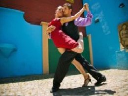
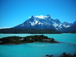
Argentina Travel Facts Population: 36 million Capital: Buenos Aires Language: Spanish Religion: Roman Catholic Currency: Pesos : divided into 100 centavos Time: GMT minus 3 hours Industries: Cereals, meat, linseed, wool, textiles, hides/leather Visa: Please consult us for visa requirements Shopping Leather goods, saddlery, ponchos, onyx and silver handicrafts, honey. Climate Spans sub-tropical to sub-Antarctic climate. In the north, hot wet summers and long dry winters. South is arid and windy with short cool summers. Brief History Initial attempts by the Spanish to colonise failed, as had earlier efforts by the Incas to extend their empire southwards. A colony was secured in Buenos Aires in 1592 and Argentina was part of the vast vice royalty of Peru until 1776 when it became part of Rio de la Plata. In 1806 a British fleet captured Buenos Aires, the Spanish viceroy fled by the British were soon ousted by the portenos (inhabitants of Buenos Aires), who gaining confidence, sought their independence under San Martin in 1816. Internal conflict followed until a federal constitution was set up in 1853. From the late 19th century in Argentina military dictatorships ruled. In federal constitution was set up in 1853. From the late 19th century in Argentina military dictatorships ruled. In 1946 Lt. General Peron became president, based on alliance between army and labour. Conditions for workers improved but the economy plummeted and following his wife's death in 1955 he was overthrown by a military revolution. The economic situation deteriorated further and led to political violence and industrial unrest. A military junta took over in 1976 and guerrilla warfare was repressed. General Viola was elected president in 1981 but removed from power by General Galtieri who proceeded to launch an invasion on the Falkland Islands, a British crown colony in 1982. A British task force sailed to the South Atlantic and a short war followed. Britain retained the islands and Argentina lost confidence in the military junta and as a result a democratically elected civilian government, that is gaining respect for its honesty and economic control, was elected. Buenos Aires Few cities are enjoyed as ten million Portenos enjoy theirs. This is the Argentine capital, their centre of manufacturing, banking, culture, and intellectualism, the place where they have fun. Ardent enthusiasm rises like balloons in the good breezy air - buenos aires - no smog here. Buenos Aires was built on human energy, not natural splendours. If you can take the pace, the place is infectious. There are only a few great cities with the advantages that Buenos Aires offers. Despite its size, Portenos have not abandoned the centre for satellite cities around the fringe. Near the redesigned Plaza de Armas, now called Plaza de Mayo, are superb restaurants, movie theatres, boutiques, book stores, art galleries, and the elegant pedestrian street, Florida, leading to the cities finest hotels. Most sights within walking distance. We, who are accustomed to fear after dark, don't trust safety on the streets at first. But watch the Argentines and believe it. The streets are jammed at ten, and crowded at midnight, not until two o'clock in the morning do the strollers begin to wear out and go home. This is true in summer and winter and even on weekdays. One out of every three Argentines live in Buenos Aires. They fine it irresistible even though it sits alongside a muddy estuary that requires constant dredging. Portenos go to Mar del Plata, Uruguay's Punta del Este, or Rio when they want sand. Almost everything you'll want to see in Buenos Aires curves along the River Plate between La Boca (the mouth) and Tigre, a suburb on the delta. Houses in La Boca- at least those along the little lane, Caminito - are pink, blue green and any other brilliant, leftover colour from ships in port. This clannish tenement area was settled by Genoese sailors whose descendants stay on proudly. Artists gather here to sell their work. Beloved by artists, musicians, intellectuals, and tourists for its narrow sidewalks and wrought iron grills on colonial windows nearby . The Parana Delta is larger than Holland and Belgium combined. With its natural canals, Tigre at the mouth of the delta could be compared with Amsterdam, Venice or Bangkok. Many of the 40,000 inhabitants live in houses on stilts and send their children to school on bus-boats. La Recoleta cemetery with its extravagant, original mausoleums (Eva Peron is buried here in a very plain one) is well worth a visit as is the Recoleta district with its expensive outdoor cafes and restaurants. There are many impressive shopping malls in Buenos Aires, Patio Bulrich and Alto Palermo, which offer very expensive boutiques with excellent quality leather goods. As the US dollar is widely accepted in Buenos Aires there is no need to change for the Argentina Peso. Two historic dates 25th May 1810 - The first government independent of the Kingdom of Spain. 9 July 1816 - Independence day. Birth of the Republic of Argentina San Carlos de Bariloche Bariloche is the gateway to the Patagonian Andes and a base for exploring the Nahuel Huapi National Park, the most important national park in Argentina. Its Swiss-style alpine style architecture is of great interest and has given it the name of Switzerland of the Americas. I would liken the scenery to Queenstown multiplied by 100. In the main plaza there is a clock which on striking twelve, four wood carved figures appear, an Indian, a missionary, a conquistador and a farmer. The scenery around Bariloche is just stunning and this is the skiing centre of Argentina with the season running from July to September. This means many cable cars and ski runs to get fantastic views from the top of the mountains. Bariloche – things to do Approximately 15 mins from the airport to downtown Bariloche Wander through the town and sample some of the Finest chocolate in the world Take a 45 minute sightseeing train around Bariloche departing from the main square Stroll along the lakeTake the cable car to Mount Otto for terrific views. A bus departing every half hour from the Teleferico Booth (outside Aerolineas) will take you to the base to catch the cable car. There is a classic revolving restaurant at the top well worth a visit to take in the spectacular views. Best coffee/cake in town at Bienvenido or Turista Friends restaurant a great snack bar for lunch or alight meal Restaurant La Marmite is superb - we highly recommend trying the fondue |
||
Travel Facts Population: 8 million Capital: La Paz Language: Spanish, Quechua, Aymara Religion: Roman Catholic Currency: Bolivianos divided into 100 centavos Time: GMT minus 4 hours Electricity: 220v 50c Visa: Please consult us for visa requirements Shopping Knitted and woven alpaca garments, gold and silver jewellery, Inca flutes, wooden carvings. Climate Hot sunny days are likely year round except in December which is the rainy season. Average temperatures are around 10-17 degrees Centigrade during the summer months and fall to between 0-17 in winter. We can expect hot sunny days a bitter cold evenings while in La Paz. General Facts Bolivia may have suffered an average of one coup per year since independence from Spain in 1825, but it has had civilian rule since 1982. The President is elected by popular vote every four years under the 1967 constitution. The country is divided into nine departments, each controlled by a Delegate appointed by the President. Bolivia has La Paz for an effective capital, as the seat of the Government and Congress, with the legal capital being the small city of Sucre, where the Supreme Court sits. Bolivia is the poorest Southern American republic. Over half the population subsist on agriculture. Until the collapse of prices in 1985, tin was the major export earner for the country. Now Bolivia still mines quantities of gold, silver and zinc. Natural gas is exported. The biggest money-spinner in Bolivia is coca growing, which the Government hopes to curb - it employs thousands of peasants and contributes an undertermined but significent sum to the office economy. In 1997, Bolivia showed the first positive growth of its economy in six years, and hopes are that the trend will continue. La Paz At dawn mist and clouds can be seen rising from the lower valleys until the sun peers above the Andes and bathes the surrounding hills with hues of red, ocher, and blue. At dusk, as the sun settles on the Altiplano flatlands surrounding the valley of La Paz, a reddish glow envelops the city's greatest landmark, the snowy peaks of the 21000 ft Illumani Mountain. With the Andes and deep blue skies as a backdrop, Aymara Indian women, children in tow, sell their wares at roadside market stalls facing tin-and straw-covered adobe homes. The barren plateau known as the Altiplano is our first introduction to the city of La Paz. The Altiplano hides the presence of a thriving metropolis of one million inhabitants that opens up at its edge. Without warning, the plateau breaks and reveals below a deep jagged valley covered with adobe and brick homes clinging to the hillside. Skyscrapers, rising to meet the jagged hills of the valley, cast shadows over adobe, stone and brick homes, cobblestoned streets and tree-lined plazas that hide the rich and colourful traditions, growing out of centuries of Spanish conquest, revolution, and Amayra folklore. And only three hours by car, on the eastern slops of the Andes, are banana and orange groves. Before the sun is out men, women, and children, wearing bowler hats and multilayered skirts begin their daily trek by foot or bus into the centre of La Paz. By the time the sun has risen, vendors are in place in the markets, ready to offer a wide variety of vegetables, fruits, whole pigs, clothing, household goods, and steaming hot coffee. Aymaras live in the surrounding hills and market areas. Below are the homes and workplaces of a Creole class that has identified itself more with its European forebears than with the Indians who make up 70 percent of the country's population. The city then descends several thousand feet to the neighborhoods of Obrajes, Calacotc, and Irpavi, where diplomats and wealthy Bolivians live in sumptuous homes. Witches Market A block above the church you will find Aymara speaking women wearing the traditional bowler hat offering medicinal cures still used by the callawayas, the ancient medicine men who attended the Inca courts and used quinine to cure malaria long before it was adopted by Western medicine. Roadside stands offer herbs for curing rheumatism, stomach pains, etc. Also available are llama foetuses, incense, small bottles with sweet syrups, nuts, wool, copal, and grease - items that are used for white magic ceremonies and to protect a dwelling from evil spirits. For about two dollars you can purchase a bag of offerings to the goddess of earth, the pachamama, and be assured of a bountiful year. Whenever construction of a home begins, these ingredients are burned and the ashes buried in the corner during a ceremony known as the challa. Most Bolivians also challan, or bless their belongings once a year by sprinkling alcohol and streams of coloured paper over them. The Sagarnaga continues up to market areas, where shoeshine boys, vendors and peasants offer their wares. Tucked away in courtyards and alleys are tambos, where bananas, oranges, and coca leaves are available. Coca leaves, from which cocaine paste is made, are widely used in restaurants as a tea, or chewed by peasants to help fend off the effects of hunger and tiredness. Food Many Pacenos, as residents of La Paz call themselves, take time off mid morning for a break to eat a saltena, a hearty beef, olive, hard-boiled egg, potato, and pea stew wrapped in a dough that is Bolivia's contribution to haute cuisine. They are sold throughout the city but be careful not to buy them off the street. Because of the altitude it is wise to eat the main meal at lunch time and lightly in the evening. A siesta after lunch is enjoyed by many and you will find many of the shops, including the Post Office close between 12.30 and 3.00. Valle de la Luna (Valley of the Moon) Actually this isn’t a valley at all, but rather a bizzare eroded hillside maze of canyons and pinnacles technically known as badlands. It lies about 10kms down the canyon of the Rio Choqueyapu from the city centre. La Paz - finding your way around To get your bearings and capture some of the color, bustle, and contrasting life-styles, start your visit by taking a walking tour of downtown. You can spend several days just exploring the roads and valleys that branch off from the San Francisco church. Bordering it is the Calle Sagarnaga, lined with dozens of small shops stocked with leather goods, weavings, alpaca sweaters, silver, and antiques. Vendors on the street sell old coins, irons heated with charcoal, silver or pewter ware, and small stone carvings made by the Aymara or Quechua people who inhabit the Altiplano. Adjacent to the San Francisco church you will find a handicraft gallery sponsored by the Catholic church. Open Monday to Friday 10-1 and 2.30-7.00 and weekends in the mornings only, you'll find weavings, sweaters, and handcrafted Bolivian instruments such as the quena, zampona tarka, and charango, a stringed instrument with a backing made from the carcapace of an armadillo. Tiwanaku (Tiahuanaco) – this is an optional trip Bolivia's most important archaeological sight, Tiahauanaco, is located fifty miles west of La Paz. It was once the centre of one of the most ancient cultures in the Americas. Its monumental stone figures, stone courtyard, and sun gate give a glimpse of a civilisation that mysteriously surfaced around 600 BC and disappeared around AD 1200. Now located twenty miles from the shores of Lake Titicaca, it is believed to have once been near the shores of the lake. Little is known about the Tiahuanaco people who constructed the great ceremonial centre on the southern shore of Lake Titicaca over 1000 years ago. Archaeologists generally agree that the civilisation that spawned Tiahuanaco rose about 600 BC and that by 1200AD the group had melted into obscurity. Evidence of its influence, particularly in the area of religion, has been found throughout the vast area that later became the Inca Empire. The most imposing monument is the Gate of the Sun, which is thought to be a solar calendar. It is part of an elaborate observatory and courtyard that contain monoliths, the door of the Puma, and a subterranean temple. It provides a glimpse into the ancestry of the Aymara people, many of whom still inhabit the area. This is an optional full day excursion from La Paz. The great ruins lie about 2 hours away from La Paz towards Lake Titicaca. Lake Titicaca Titicaca is the world's highest navigable lake and has shaped life among the high-cheekboned, dark skinned people who inhabit its shores and islands. When dry land is not enough, it is also possible to create artificial habitats. The Uros Indians live on floating reed islands in the lake. The reeds, called totora in the local language, are also used for the distinctive boats which are used to ply the placid but frigid waters. The women are accomplished embroiderers. Logistics Covering more than 3000 square miles (8,000 sq km) this massive lake has more than 30 islands. Don’t let the sunny skies and gentle spread of the land surrounding the lake fool you into thinking it is hospitable. It’s waters are frigid all year round, as befitting a lake poised at 13,000 ft above seat level (4,000 metres). According to folklore, it was from Titicaca that sprang one of the most important Indian cultures the world has ever known -–the Incas. For them, the legend has it that when the Spanish reached Cusco, the Indians took the two-ton (1800 kg) gold chain of Inca Huascar from it’s resting place at Koricancha (Cusco)., The Temple of the Sun, and hurled it into the lake to hide it from the invaders. Some years agao oceanographer Jacques Cousteau spend eight weeks with a mini-submarine exploring the lake. He found no gold but he did discover a giant (20 inches (60cm) tri-coloured frog that apparently never surfaces, Floasting Reed Islands - Islas de los Uros On Lake Titicaca’s surface are its islands, the best known being the floating reed islands of the Uros Indians. Local superstition has it that black blood coursed through the Uros’ veins, allowing them to survive the frigid nights on the lake. The last full-blooded Uros died in 1959 but the islands current inhabitants, a mix of Uros, Amyra, and Quechua Indians – follow the Uros ways. They fish, hunt birds and live off the lake plants, including the all-important reeds used to make their homes, build their boats and form the base of their islands. Puno Puno is proud of its Indian heritage and has kept up a strong folklore and music in its more unfiltered forms. There is a seemingly endless cycle of festivals and saint days which are celebrated with dances and music. The 'devils masks' carved and painted wooden disguises for these rites, are invaluable pieces of folk art. At the southernmost part of the lake, the people have maintained a separate ethnic identity from the Quechua speaking people of the north. These people speak Aymara, and share community and language ties with the indigenous of Bolivia. Copacabana Copacabana is an attractive, sleepy little town on the lake where we will stop for lunch after border formalities crossing from Peru into Bolivia It has a heavily restored cathedral containing a famous 16th century miracle-working Dark Virgin of the Lake, also known as the Virgin of Candelaria, the patron saint of Bolivia. The cathedral itself is notable for its spacious atrium with four small chapels, the main chapel has one of the finest gilt altars in Bolivia. The basilica is clean, white, with coloured tiles decorating the exterior arches, cupolas and chapels. Vehicles are blessed in front of the church daily, especially on Sunday. There are 17th and 18th century paintings and statues in the sanctuary and monastery. On the headland which overlooks the port and town, Cerro Calvario, are the Stations fo the Cross. You will get time to visit the church while the bus stops here for lunch. (Usually at last an hour here) You will also change buses here as the Bolivians do not allow Peruvian buses to drive all the way through to Puno !! Isla del Sol Legend has it that the Sun placed his two children, male and female, on the Island of Lake Titicaca, later named as Island of the Sun. They were to teach the barbaric people better living conditions on the earth. Manco Capac and his wife Mama Ocllo (Huaca) are said to be the two children. Hence the Inca civilization had begun. Today this island is a joy to visit. No cars, no dogs, and the local people farming the Inca terracing as they have for thousands of years |
||
Travel Facts Area: 8,511,954 sq km Population: 166 million Capital: Brasilia Language: Portuguese Religion: Roman Catholic mainly Currency: Real - divided into 100 centavos Time: GMT minus 3 hours Business Hrs: 0900-1800 (Mon-Fri) Visa: Please consult us for visa requirements Shopping Indian artefacts, gemstones and jewellery, lace, leatherwork, pottery, wood carvings, soapstone and bone carvings and cigars plus coffee. Climate Brasil lies between the Equator and the Tropic of Capricorn, and temperatures range from 18c in sub-tropical south to 25C in equatorial north. Rainy season is from January to June, although Northeast Brasil is the driest and Amazonia the wettest. The People You’ll find the people very vibrant and every colour from white to black – and every shade in between. In Rio especially they love the beach and to keep their bodies in shape. Brief History The Portuguese discovered Brasil in 1500 although colonisation was slow due to their interests in the east. A feudal principality was established but replaced by a Viceroy in 1572. Sugar can was introduced and Incian and African slave labour used. There was much intermarriage which produced a mix of races. An earlier attempted invasion by the Dutch in 1624 prompted a nationalistic response and 1789 saw the first revolt against Portuguese rule. In 1808, because of the Napolenonic wars, the Portuguese Royal Family moved court to Brasil and the colony’s fate was decided. The King returned to Portugal in 1821 and, against the Portuguese Governments wishes left his son Pedro as Regent. Pedro proceeded to declare Brasil’s independence and became constitutional emperor. His successor abolished slavery and was subsequently deposed in 1889 and Brasil became a republic. Apart from an initial monarchist rebellion a time of prosperity and expansion followed. Recent times have seen an instability in government, and increasing corruption leading to military intervention, although presidential elections in 1985 saw a move away from the military regime and the current democratic government is bravely fighting against super inflation and high unemployment. Seven years ago they changed the currency from Cruizeros to the Real in a bid to curb this rampant inflation. |
||
Travel Facts Population: 15 million Capital: Santiago Language: Spanish Religion: Roman Catholic Currency: Chilean Pesos divided into 100 centavos Time: GMT minus 4 hours. Offset plus 1 hour for daylight saving Electricity: 220v 50c Visa: Please consult us for visa requirements Credit cards: Visa and Mastercard common. Amex less useful Climate Complex and varied. Mediterranean type climate in central Chile, with cool temperate conditions in the south and a stormy extreme south. Santiago January 19.5 C - July 8 C. In other words it will be warm and fresh ! Geography Stretching 4200 km along the West Coast of South America between the mighty Andes and the Pacific Ocean, Chile offers a sharp contrast of desert in the North, pleasant farmland in the centre and a lake region of breathtaking beauty in the south. Most Chileans are of European descent, but indigenous traditions persist. In the north, Aymara Indians farm the Andean foothills and tend llamas and alpacas on the Altiplano. The constitution allows a popularly elected president and the establishment of a Congress with a 46 member Senate and a 120 member Chamber of Deputies. The president resides in Santiago and administration is highly centralised. Over a third of Chile's population reside in Santiago and its suburbs. The Chilean people are exceptionally hospitable and frequently invite foreigners to their homes. History The first traveller to reach Chile barely gave it a glance. Hernando de Magallanes left his name only in 1520. Later Pedro de Valdivia travelled south along Camino del Inca and founded Santiago in 1541. For 300 years Chile's original inhabitants (Mapuche) successfully defended against Spanish encroachment. Independence lasted until 1881 when the government imported German and Swiss colonists. Now, Chileans are a mixture with the lightest hair, skin and eyes to be found at the top of the hierarchically organised society. Santiago Since the 1970's Chile's capital has grown out and up. It continues to sprawl, while high-rises have sprouted in the downtown area and in Providencia, a suburb which may become the city's commercial and financial centre. With over four million inhabitants, Santiago is one of South America's largest cities. History of Santiago Indians nearly obliterated Santiago six months after Pedro de Valdivia founded it in 1541. Even in the late 16th century, only 700 Spaniards and mestizos, plus Indian labourers and servants, inhabited its 200 adobe houses. Occasionally flooded by the Rio Mapocho, it still lacked a safe water supply and communications between town and country were hazardous. By the late 18th century, new dykes restrained the Mapocho, and improved roads carried increased commerce. By the 19th century, a railway linked the capital with more than 100,000 inhabitants, to the port of Valparaiso. Poverty and paternalistic fundos drove farm labourers and tenants north to the nitrate mines and then into the cities, from 1865 to 1875, Santiago's population rose from 115,000 to more than 150,000. Industrialisation created jobs, but never enough to satisfy demand. In the 1960's continued rural turmoil resulted in squatter settlements around Santiago. Planned decentralisation has eased the pressure, and regularisation, including granting of titles, has transformed many callapas, but they still contrast with affluent eastern suburbs. Valparaiso (Valpo) Description: 120 km (74 miles) NW of Santiago; 8 km (5 miles) S of Vina del Mar Valpo is Chile's principal port and second-largest city. Despite its size, it is Chile's most distinctive city and one of South America's most intriguing. Occupying a narrow strip of land between the waterfront and the nearby hills, its convoluted centre has distinctive, sinuous cobbled streets, and is overlooked by precipitous cliffs and hilltop suburbs which are accessed by funicular railways and stairway footpaths. It is conducive to maze-like strolls and rides on the funicular, and its natural history, fine arts and maritime museums are justly famed. Vina del Mar Description: 120 km (74 miles) NW of Santiago; 8 km (5 miles) N of Valparaiso Viña del Mar is one of Chile's most fashionable beach resorts. The town was founded in 1874 as a weekend retreat and garden residence for the wealthy elite from Valparaíso and Santiago, and it has remained a top beach destination for Santiaguinos ever since. Most simply call the city "Viña" The sight of Viña del Mar's attractive homes, manicured lawns, and golden beaches dotted with colourful surfboards is something of a contrast to the ramshackle streets of Valparaíso. There are plenty of fine beaches here. The city is divided into two sectors: the downtown and the beach-front. |
||
Travel Facts Area: 272,045 sq km Population: 12.65 Capital: Quito Language: Spanish, Quechua Religion: Roman Catholic Industries: Agriculture, mining, manufacturing, construction,military Currency: US dollar only Time: GMT minus 5 hours Business Hours: 0900-1730 (Mon-Fri) Electricity: 110V 60Hz AC Visas: Please consult us for visa requirements Climate Instead of the four seasons, Ecuador has wet and dry seasons. The local weather patterns vary greatly, depending on the area. Coastal areas are hot and rainy season from January to April. In the Oriente (jungle area) it is usually almost as hot as the coast and rains most months. September to December are the driest, July and August the wettest. The dry season in the highlands is June to September and a short dry season occurs during December. Daytime temperatures in Quito average high of 20C to 22C and a low of 7C to 8C all year round. Capsule History The history of pre-Inca Ecuador is lost in a misty tangle of time and legend, and the earliest historical details date back only as far as the 11th century AD. It is commonly believed that Asian nomads reached the South American continent by about 12,000 BC and were later joined by Polynesian colonizers. Centuries of tribal expansion, warfare and alliances resulted in the relatively stable Duchicela lineage, which ruled more or less peacefully for about 150 years until the arrival of the Incas around 1450 AD. By the mid 1400's the south was in the hands of the Canari people who defended themselves fiercely against the Inca invaders. It was some years before the Inca Tupac-Yupanqui was able to subdue them and turn his attention to the north. During this time, a Canari princess bore him a son, Huayna Capac. He succeeded his father on the Inca throne and spent years travelling all over his empire, from Bolivia to Ecuador, constantly putting down uprisings. He strengthened his position by marriage to Paccha daughter of defeated Cacha Duchicela, and produced a son, Atahualpa. Huayna Capac died in 1526 and left his empire to two sons, thus dividing the Inca Empire for the first time. In the same year the first Spaniards landed near Esmeraldas in northern Ecuador. Meanwhile the rivalry between the two Incas, Huascar of Cusco and Atahualpa flared into civil war. Quito held out for two years but was eventually razed by Atahualpa's general, Rumiñahui, who preferred destroying the city rather than losing it intact to the invading Spaniards. Quito was refounded in December 1534. Today, only one intact Inca site remains in Ecuador - Ingapirca, to the north of Cuenca. Pizarro landed in Peru in 1532. Francisco Pizarro appointed his brother governor of Quito in 1540. Although life was abysmal for the indigenous people under Spanish rule, there were no major uprisings by the Ecuadorian Indians. Spain ruled the colony from Lima, Peru, until 1739, when it was transferred to the viceroyalty of Colombia. As a Creole middle class began to emerge, there were several attempts to liberate Ecuador from Spanish rule. Independence was finally achieved by Simón Bolívar in 1822. Full constitutional sovereignty was gained in 1830. The country's internal history has since been marked by fierce rivalry and occasional open warfare between the church-backed conservatives in Quito and the liberals and socialists of Guayaquil. Ecuador remained a peaceful colony for centuries where agriculture and the arts flourished. Cattle, bananas and other products were introduced to Europeans. Life was comfortable for the ruling Spaniards but Indians and mestizos were treated abysmally. systems of forced labour and tribute were not only tolerated but encouraged, and it is by no surprise that by the 18th century there were several uprisings of Indians against their Spanish rulers. The first serious attempt at independence was made in 1809 by a group who managed to take Quito but only lasted 24 days. Independence was finally achieved when Simon Bolivar, freed Colombia in his march southward from Caracas in 1819. It was not until the decisive battle fought on 24 May 1822 that Ecuador was entirely liberated from the Spanish rule. Ecuador's most recent period of democracy began in 1979. Over the last 100 years, assassinations and political instability have increasingly invoked military intervention, and the 20th century has seen more periods of military rule than of civilian. In 1941, neighboring Peru invaded Ecuador and seized much of the country's Amazonian area. The 'new' border between the two countries - although formally agreed upon and ratified by the 1942 Rio de Janeiro treaty - remains a matter of dispute., as a comparison of Ecuadorian and non-Ecuadorian maps will show. Border region skirmishes have occasionally flared up, usually around January, the month when the treaty was signed. The squabbling has died down in recent years, as both countries work to impress potential foreign investors (who tend to be scared off by territorial skirmishes), and a treaty is in the works that should finally bring an end to this dispute. Despite its history of internal rivalry and border conflicts, life in Ecuador has remained peaceful in recent years. Ecuador is currently one of the safest countries to visit in South America. Culture of Ecuador Straddling the equator, the Ecuadorian coast rushes up to snow-capped volcanoes then falls away to hot Amazon jungle--all in a country the size of the State of Colorado! It shares a long-contested border with Peru to the south and east, and is bounded by Colombia to the north and the Pacific Ocean to the west. The country can be divided into four regions: the western coastal lowlands, the central Andean highlands, the eastern jungles of the Amazon basin and - some 1000 KM (620 miles) west of the mainland - the Galapagos Islands. Thanks to its agreeable climate and patchwork of habitats (alpine grasslands, coastal swamps, tropical rainforest), Ecuador is one of the most species-rich nations on earth, and ecologists have dubbed Ecuador a mega diversity hotspot. The Amazon basin, east of the Andes, is an almost impenetrable tangle of rainforest known to Ecuadorians as the Oriente (the East). Although the Amazon itself does not flow through Ecuador, all rivers east of the Andes eventually empty into the mighty river. Ecuador claims two of the ten biological hotspots of biodiversity in the world. The Andean highlands - the country's backbone - are composed of two volcanic ranges separated by a central valley. The capital city of Quito is nestled in the Northern end of this valley at 2850 meters above sea level, just 22 km (14 miles) south of the equator. Inhabited for centuries by Andean Indians, roughly half of Ecuador’s population lives amidst these rugged mountains. Religion, Language and Food The predominant religion is Roman Catholic, but there is a scattering of other Christian faiths. Indigenous Ecuadorians, however, have blended Catholicism and their traditional beliefs. An example is the near synonymous association of Pacha Mama (Mother Earth) and the Virgin Mary. Spanish is the main language throughout Ecuador, although most highland Indians are bilingual, with Quechua being their preferred language, while Spanish is only learned in school. When bargaining in rural markets, a Quechua word or two will not only endear you to the vendors, but usually get you an extra orange or more juice! Several small lowland groups speak their own languages. English is understood in the best hotels and in airline offices and travel agencies, but it's of little use elsewhere. Ecuadorian food consists mainly of soup and stews, corn pancakes, rice, eggs and vegetables. Seafood is excellent, even in the highlands. Local specialties include ceviche, seafood prepared in lemon juice; lechón, suckling pig; and cuy, whole roasted guinea pig;however, some delicacies may only be for the most adventurous stomachs! Quito - city of eternal spring At 2850 metres above sea level and only 22 km south of the equator, Quito has a wonderful spring-like climate. It is in a valley flanked by mountains and on a clear day several snow-capped volcanoes are visible from the capital. Few cities have a setting to match that of Quito, the second highest capital in Latin America. The city is set in a hollow at the foot of the volcano Pichincha (4794m). It was an Inca city, refounded by Sebastian de Benalcazar,Pizarro's lieutenant, in 1534. The city's charm lies in its colonial centre, where cobbled streets are steep and narrow dipping to deep ravines. Through this section hurries the Machangara River, nowadays too polluted to wash clothes in. Westwards the valley is closed by Cerro Panecillo. From its top, 184m above the city, there is a fine view of the city below and encircling cones of volcanoes and other mountains. there is a statue on the hill to the Virgen de Quito; Mass is held in the base on Sundays. There is a great view from the observation platform up the statue. With a population of about 1.2 million Quito is Ecuador's second largest city. It can be divided into three segments. The centre is the site of the old town, which has whitewashed and red-tiled houses and colonial churches. The north is modern Quito, with major businesses, airline offices, embassies, shopping centres and banks. This area also contains the airport and middle and upper-class residential areas. The south consists mainly of working-class housing areas. Quito was a major Inca city that was destroyed by Atahualpa's general, Ruminahui, shortly before the arrival of the Spanish conquistadors, there are no Inca remains. The present capital was founded on top of the Inca ruins by Sebastian de Benalcazar on 6 December 1543, and many colonial buildings survive in the old town. In 1978, UNESCO declared Quito one of the world's cultural heritage sites, and building and development in Quito's old town is now strictly controlled. There are few modern buildings next to centuries-old architecture, and no flashing neon signs to disrupt the ambience of the past. Things you could do during your day in Quito: Teleferico Quito’s latest and greatest tourist attraction opened to the public July 2, 2005 and offers some of the most spectacular and most easily accessible views of the city. Eighteen gondolas soar up the walls of the mountain range to the west of Quito leading to the Pichincha Volcanoes. The ride lasts only 10 minutes but takes you to an altitude of 4050 m (13,300 ft). At the top, there is a grandstand-esque lookout point complete with coffee, snacks, horse rental and oxygen for the faint of breath. Walk to the second floor of the grandstand and head outside; there are some excellent hiking trails leading to more views of Quito and of the Pichincha Volcanoes, which are snowcapped time to time throughout the year. At the base of the mountain, there is popular Vulcano Park, an amusement park, and a slew of classy restaurants, cafes and gift shops. Mitad del Mundo (the centre of the world) This is the most famous excursion from Quito, taking you to the equator. Here, a large monument houses a viewing platform and an excellent ethnographical museum. There is also a planetarium, and wonderful scale model of old Quito town. So you can straddle the world – with one foot in the northern hemisphere – the other in the southern hemisphere – what fun Otavalo Otavalo is in beautiful countryside about 2 hours north of Quito. The town is notable for its indigenous crafts (primarily textiles) and its enormous Saturday market which is a must for visitors to Ecuador. (the market actually goes all the time – just more full on on Saturdays and very crowded). This town of 22,000 inhabitants and the market dates from pre-Inca times, when jungle products were brought up from the eastern lowlands and traded for highland goods. The most evident feature of the otavalenos culture is their traditional dress. The men wear long single pigtails, calf-length white pants, rope sandals, reversible grey or blue ponchos and dark felt hats. The women are very striking, with beautifully embroidered blouses, long black skirts and shawls, and interesting folded head cloths. they also wear bright jewellery, many strings of gold coloured blown-glass beads around their necks, and bracelets made of long strands of red beads. The inhabitants of Otavalo are mainly whites or mestizos. There are about 40,000 Indians, most of whom live in the many nearby villages and come into Otavalo for market day. We will spend the morning visiting some of the nearby villages like Peguche, Illuman and Cotacachi – known for it’s reasonably priced and very well made leather goods. Our friends in Otavalo are working hard towards all the villages getting electricity and running water. At present water has to be carried from taps in the village. Calderon 32km north of Quito is where the miniature figurines are made of bread; you can see them being made and prices are much lower than in Quito. Especially attractive is the nativity collection. Banos This small town, famous for its hot springs lies at 1800 metres above sea level giving it an agreeable climate. The surroundings are green and attractive and offer good walking and climbing opportunities. Banos is also the gateway to the jungle. The Santurio de Nuestra Senora de Agua Santa and museum within the basilica are worth seeing. There are two hot baths in town with changing rooms and bathing costume rentals. Best known bath is Piscina de La Virgen by the waterfall. It is possible to go mountain biking, horse riding or rafting from Banos. |
||
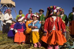
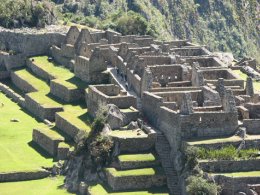
Travel Facts Area: 1,285,220 sq km (3rd largest country in SA) Population: 29.5 Million Capital: Lima Language: Spanish, Quechua, Aymara Religion: Roman Catholic Government: Constitutional Republic Industries: Fishing, sugar, cotton, coffee, iron, copper, silver Currency: Sol divided into 100 centavos, aprox Sol2.8=1US$ Time: GMT minus 5 hours Business Hours: 0900-1940 (Mon-Fri) Electricity: 220 volts.Sockets are a mix of European, 2 pronged round & US flat pin Visas: Please consult us for visa requirements Climate Coastal Peru is cool, cloudy and arid, with onshore winds cooled by the Humboldt current. Temperatures are cooler again up in the Andes with average temperatures of 0-18 C at Cuzco during April – October , with most rainfall between October and March. The Amazon basin has warmer humid conditions with average temperature between 20-30C during April – October . Money The Peruvian currency is the Nuevo Sol ($) and is divided into 100 centavos. Notes: $10 / $20 / $50 / $100 Coins: $0.10 / $0.20 / $0.50 / $1.00 / $2.00 / $5.00 Food In Peru the basic diet focuses around chicken, beef and seafood, mostly with potatos. Soups are also common and good value. “Ceviche”, “Escabeche” are fish base – popular dishes. An interesting local specialty is “Cuy” and it is roasted guinea pig. In most of the larger cities and towns you will find and array of international cuisine. There are pizzerias on every corner. In places like Cuzco even Indian and Japanese restaurants have opened. History When Pizzaro arrived in 1532, the Inca Empire was at its height but in a state of disarray and civil war following the establishment of a second centre at Quito. The Spanish founded their capital and viceroyalty at Lima, and enjoyed considerable prosperity from Inca gold and silver. Although successful in their conquest they never totally suppressed the culture and there were a number of Indian uprisings, which finally gained the support of the local born Spaniards. With the help of San Martin's Argentine troops independence was declared in 1821, though much of the country remained in the hands of the viceroy. It was Bolivar and Sucre who completed the defeat of the Spanish at the battle of Ayacucho in 1835. Gen Castilla established political stability and developed the economy during the 1850's, but prosperity was undermined during the War of the Pacific, when nitrate-rich provinces were lost to Chile in 1883. Since World War II the country has depended on aid from USA and has witnessed a series of military coups, the most recent in 1975. In 1980, Fernando Terry was elected president, but he was replaced in 1985 by Alan Perez, who immediately challenged existing monetary rules by limiting Peru's debt payments. Lately Peru has been making considerable economic progress . Current President is Alan Garcia Lima - City of Kings Lima is the door to the rest of Peru and was originally called the "City of Three Kings" because it was founded on that religious feast day, the Epiphany. For most of its four and one half centuries of existence, Lima has seemed to deny that it belonged to the rest of Peru, which was vastly Indian, deeply rooted in a non-Occidental culture, and handicapped by geographical obstacles which would only be overcome through austere sacrifice. Lima was an administrative centre for the Spanish Empire, when Peru gained its independence from the motherland, little changed. Lima remained a remote decision-maker in the lives of most Peruvian provincials and the seat of economic and political power. Lima started as an extension of a vast world empire and then aspired to be a European capital transplanted to South America. Fifty years ago, Lima was a city with half a million inhabitants and an urban infrastructure which had been installed twenty years before. Lima today holds more than seven million, a full third of the nations 22 million. Most Lima residents are provincial migrants and their offspring who came to the capital seeking a better life. Even under optimum conditions, it would have been difficult to keep up with the populations growth - paving streets, providing drinking water, sewage disposal facilities, and electricity, providing children's education, health, and other services. There is optimism that the new government is making positive strides. There has sprung up many residential districts such as Miraflores, with its tree lined streets and fashionable restaurants and boutiques. But parallel to this has come another urban phenomenon. Provincial migrants have moved into vacant terrain, usually sand dunes or wasteland to the south, east and north. Ringing Lima, these settlements are known as shantytowns. City Tour Visit the Colonial City of Kings with stops at the Palacio de Gobierno (Government Palace) built from 1921 to 1938, San Francisco Church with Arabic influences finished in 1674 seeing its carved 'Sillera Coral" (1622) and Jose de Rivera's paintings (1672) The monastery is famous for Sevillan tilework and panelled ceilings in the cloisters (1620). There are catacombs under the church and part of the monastery. Also visit the city's Cathedral with the splendid carved stalls (mid 17th century), the silver covered altars surrounded by fine woodwork; mosaic covered walls bearing the coat of arms of Lima and Pizarro. There are many museums to see in Lima and we will take the time to visit the following one which covers all the different culture periods of Peru and has some stunning gold artefacts. Museo de Oro (Gold Museum) - 18th block Prolongacion Av Primavera (Av Molina 1110) Monterrico. This world famous underground museum contains precolumbian gold, silver and bronze, ceramics, weavings, mummies etc. This is an extraordinary collection of 6500 pieces (necklaces, idols, funeral masks, weavings, ceramics etc) of the Mochica, Nazca, Chimu and other cultures from the particular collection of Mr Miguel Mujica Gallo. In addition there are numerous other artefacts of silver and precious stones such as lapis lazuli, emeralds and pearls. The second floor of the building houses an Arms Museum which is reputed to be one of the best in the world. The third floor (recently opened) has an extraordinary exhibition of textiles specially from Paracus and other Peruvian Cultures. Pisco Pisco gives its name to the white grape brandy produced in this region, the famous PISCO SOUR cocktail is known worldwide. It is an important port of about 82,000 inhabitants and lies some 283 kms south of Lima. Use Pisco as a base to see the wildlife of the nearby Ballestas Islands and Paracas Peninsula. This area is of considerable historical and archaeological interest. The resort of Paracas is about 15km south of Pisco with better accommodation but more expensive. The Paracas National Reserve The Paracas National Reserve encompasses land and sea and is the most important wildlife reserve on the Peruvian coast. The area is particular know for its bird and marine life. The birds nest on the offshore islands in such numbers that their nitrogen-rich droppings (guano) collect in quantities large enough to be commercially exploited for fertiliser. This practice dates back from Inca times at least. The most common guano-producing birds are the Guanay Cormorant, Pervian Booby and the Peruvian Pelican. These are seen in colonies of several thousand birds. Less frequently seen but of particular interest are the Humboldt Penguins on the Ballestas Islands and the Chilean Flamingos in the bay of Paracas. The Andean Condor occasionally come down to the coast and may be seen gliding majestically on the cliff thermals of the Peninsula. Ballestas Islands Cruise around the Ballestas Islands to see plenty of birds and marine life like sea lions lying on the rocks or swimming around the boat, some species like penguins are less visible. En route see the giant figure etched into the coastal hill called 'Candelabra' similar to the figures of the Nazca Lines. Nazca Lines 114 kms south of Ica and 443 km from Lima is a town with 30,000 people, set in a green valley amid a perimeter of sand mountains. Its altitude of 619 metres above sea level puts Nazca just above any fog which may drift in from the sea, the sun blazes the year round by day and the nights are crisp. The Nazcans had a highly developed civilisation which reached its peak about AD800. Nature is not he only marvel which has been working in the desert sands. Down south of Lima, on a large barren plain are the mysterious Nazca Lines, which have bewildered archaeologist, historians, and mathematicians this century. The Nazca Lines are markings or drawings which stretch for several miles. Some thirty drawings depict animals and birds, like a monkey with a coiled tail, a hummingbird fluttering in flight, or an owl. Others form geometrical shapes. Still others are complex knots of lines which seem to have been precisely measured and laid. There are similarities between the style of some of the line patterns and that of the pottery and textiles of the same period. There are scores of theories which try to explain why a pre-Columbian culture would trace huge patterns in the sands which they would not necessarily be able to see themselves. The lines show an understanding of sophisticated mathematics and surveying techniques. The most eccentric investigators insist that the Nazca Lines show the presence of extraterrestrial beings, a kind of landing strip for flying saucers, but other theorists point to more rational schemes - a huge map of the Sierra or a celestial calendar. Dr Maria Reiche the German expert (now deceased), has lived and studied these lines for 40 years and always maintained that they represent some sort of vast astronomical pre-Inca calendar. Another theory is that the ancient Nazcas flew in hot-air balloons, this is based on the fact that the lines are best seen from the air and that there are pieces of ancient local pottery and tapestry showing balloonists, and local legends of flying men. The ONLY way to fully appreciate the giant archaeological mystery is to take a flight over the lines that are huge geometric designs drawn in the desert and visible only from the air. Flights are taken in light aircraft 4 - 6 seaters and last about 40 minutes. Chauchilla tombs When seeing the Lines from the air, you will notice that the valley countryside around Nazca looks as if it has been pockmarked by aerial bombardments. These holes are what is left by the huaqueros who rob the pre-Columbian graves. The ceramics found in burial grounds are highly prized in the world antiquity market. The Nazca culture (AD 100 to AD 800) would apply its distinctive artistic perspective to polychromatic ceramics. The paintings depict daily life and many specialists believe that the patterns contain primitive pictographic writing. In any case, these ceramics give an unparalleled perspective of the world before the coming of the Europeans, from the customs of hanging mummified heads on a man's belt as trophies of valour to wildlife in the region. The Nazca culture also made painstaking use of the scarce water sources. Today, the city is crossed by underground canals built by the Nazca culture. These waterworks - and the ceramics - are this culture's monuments. Arequipa With 634,500 people, 1011 km from Lima by road, stands at 2380m above sea level in a beautiful valley at the foot of El Misti Volcano (5822m), a snow-capped perfect cone, guarded on either side by the mountains of Chachani (6096m) and Pichu Pichu. The city has fine Spanish buildings and many old interesting churches built of sillar, pearly white volcanic material almost exclusively used in the construction of Arequipa. The climate is delightful, with a mean temperature before sundown of 23 C, and after sundown of 14 1/2C. The sun shines on 360 days of the year. Annual rainfall is less than 150mm. Because of the danger of earthquakes the churches are low, the houses have one storey only, and roofs are flat and windows are small, disguised by superimposed lintels or heavy grilles, in recent years, higher buildings with large windows have been constructed. Convent of Santa Catalina One of the most fascinating religious colonial buildings in Peru. It is a good sized complex, almost a city within a city. It was built in 1580 and enlarged in the 17th century. The convent is surrounded by imposing high walls and the 450 nuns who lived within led a completely secluded life and never ventured outside the convent. It was finally opened to the public in 1970. Also visit the picturesque parish of San Lazaro, the Moral House, the Plaza de Armas and its cathedral built in ashlar. Arequipa – “Juanita” – the beautiful girl of Ampato “Juanita” the beautiful young girl of the Ampato Volcano, was discovered on the 8 September 1995 by Anthropologist Dr Johan Reinhard, after more than 15 years of research on the “Santurios de Altura del Sur Andino” project. This was conducted jointly with Dr Antonio Chavez, under the academic support of the Catholic University of Santa Maria de Arequipa, Peru. The Ampato Volcano, with an approximate height of about 5380 metres above sea level, sheltered this beautiful Inca girl in its bosom for about 500 years or more. She must have been some 13-14 years old at the time of her death. She was offered to “Apu” Ampato (the mountain God) by the Inca priests of those days. Her discovery resulted from the erruption of the Sabancaya Volcano. Today she is shown to the modern world so that science and knowledge can profit from her age-old wisdom, for our well-being. For the many rituals that took place, the girl had to travel to Cusco accompanied by a great court of very important people of the region, being awaited and welcomed in Cusco by the Inca in person who transmitted his divinity. From that moment she accepted the reality of her death and her own communication with the mountain Gods, in this case Apu Ambato, where she would be offered in a journey without return, towards divinity. After great festivities and rituals, Juanita had to be put to sleep by a precise blow on her right eyebrow, which caused her to die. Research that is being done determines that she was subjected also to a fast which made the sedatives used work faster. It is possible, that mitochondrial studies of DNA will make it possible to to establish the genealogy of this girl. Furthermore, we will know her state of health, the illnesses to which she was subjected during her infancy, the viruses and bacteria that have affected her and that are still present in her body, the type of diet in those times and much more information that she herself will provide to us. At the moment, the remains of this beautiful Inca girl are being studied, preserved and kept in the laboratories of the Universadad Catolica by a team of scientists. The importance of this discovery is very great and the responsibility assumed by both ourselves and the University is expressed in the achievements being obtained at all levels. The challenge has been set by Juanita herself and our present and future responsibility in dealing with it is enormous. We are respectful now and always of our rich cultural heritage, especially of this king of archaeological remains. All the people and institutions involved in this research are quite excited by the scientific possibilities offered by “Juanita”, the beautiful young lady of the Ampato volcano. It is very important that the researchers and the general public remember that these remains belong to a young girl who lived and died in the time of the Incas. For this reason, the University requests that the people who come to see “Juanita” behave in a respectful way because of what she is and what she represents. Museo Sanutarios Andinos / Web page: www.ucsm.edu.pe/sanctuary Today “Juanita” lies and is available for viewing at the Museo Santurios Andinos – Calle Santa Catalina 210, Arequipa Colca Canyon Touring the Colca Valley is an unending sequence of surprises, its people, important archaeological remains, terraces, cacti, Churches, countryside, birds, llamas, traditional costumes and customs, many of them unchanged since the time of the Colony. Nature makes its grandness known, presenting the Great Canyon, more than 3400 metres deep for more than 100 km, and territory of the Condor, the mystic and majestic bird, which is commonly seen flying down this imposing and magical corner of the Andean chain. Its recent rediscovery and the possibility of access to this area has awoken the interest of scientists, journalists and famous explorers who have made documentaries, such as the BBC in London, the channel TV ABC of the USA, the Amazon expedition of Jaques Cousteau who are spreading the news of its spectacular nature, cultural and richness throughout the world. The Colca is an inter-Andean valley, initially populated and developed by the Collahuas, who were great agricultural workers and makers of irrigation canals and terraces, although there are also remains of prehistoric cultures and of course, Inca cultures. The headwaters of the valley are at 4000 metres above sea level, being exclusively used for cattle rearing, descending in a gentle slope, its ecology and agricultural area go on changing, arriving at 3000 metres, where the valley narrows, and the impressive Colca Canyon, 100km long, really begins. To the Colca, in addition to its agricultural richness, are added the rich mines of Caylloma, for which reason it was very important during the Colonial era, as can be seen from the richness of its churches, many of them of notable architecture and valuable pieces of religious art. Gonzalo Pizarro, the brother of Francisco Pizarro, the Conquistador, established the Corregimiento Collahaus in 1540. Later the Viceroy Toledo gave orders to establish Reducciones (settlements of converted Indians) obliging the rural population to live, concentrated in towns along the valley; As a result fourteen towns were formed, each one with beautiful churches, laid out in streets forming rectangles, and of course a main square as can be seen today in Yanque, Achoma, Maca and other towns in the area. In Important shelters (small caves) you can find paintings and etchings over 7000 years old, depicting hunting scenes, camelloids (guanacos, llamas etc) foxes, human figures, representations of the stars, such as the Sun the Southern Coors, birds and many other figures, which prove the passing of various human settlements over thousands of years. In various places there are found splinters of obsidian and flint. It was also very important for the Incas for their agricultural production, chiefly maize, so much that the chronicles tell that Mayta Capac had a Collahuan wife for whom he built a palace of copper in what is now the town of Coporaque, and that the first Spaniard who arrived used this copper for the shoes of their horses, finally the priest melted it down to make the bells of that important church, which was probably built at the end of the 16th century. The now famous canyon is formed by an enormous fault in the earth’s crust between huge volcanoes Coropuna at 6425 m. It was first navigated in 1981 by the Polish students of the expedition CANOANDES. The canyon runs parallel to the Cordillera de Chila, where the River Amazon has its most remote source in Mismi (5597m) and proved to be expeditions of the National Geographic Society in 1972 and the Amazon expedition of Cousteau (1982). At the summit of the snow-capped Mismi, the South African explorer, Sr Peter Rose in 1979 found a gold idol as an offering for being the source of the waters which made their fields fertile, as is traditional in the snow-capped Andes. From 1975 onwards with the works for the constructions of one of the most audacious projects of hydraulic engineering and economic development in the region, roads were built and they organised essential services of education and health, among others, for the workers who, during eight years bored nearly 100km of tunnels through the mountain chain, to take the water from the Colca River to the driest desert which existed – Las Pampas de Majes’ and to bring into production 60,000 hectares of land and to generate a potential 650,000 kW of electricity. Now the Colca Valley is one of the most important tourist places in Peru, it is visited by many tourists from all over the world. Cusco – Heart of the Inca Empire Cradled in a high Andean valley, Cusco seems to surge up from the earth. The houses made from orange-hued adobe bricks with their pottery shingles match the deep red clay tones of the soil, contrasting with the vibrant green of mountainsides. In the old core of the city, the colonial period houses and mansions are made with he stones of volcanic rock, granite, and limestone which the Incans themselves quarried to build their palaces and temples. The foundations have not been moved, even by earthquakes. The Inca past seems to spring from the bedrock. Looming over the church spires, on a hill over the city, is the monument Sacsayhuaman fortress. The narrow, cobblestoned streets wind their way along the hillsides. Cusco was the fountainhead of the Inca Empire, the most important seat of colonial power outside Lima, and a pole of development once Peru stepped into the twentieth century. It has retained a spiritual, almost mythical importance as craftsmen and artists have laboured to preserve some of Peru's greatest achievements; from the humblest crafts to native arts, from the distinctive festive music to architectural marvels. Cusco was the central spoke, or as the Incas themselves called it, the navel of the universe. The Peru that was conquered was the last advanced civilisation completely isolated from the rest of mankind. When the Spaniards, fresh from the plundering of the Aztec Empire in Mexico, set foot on the northern marches of the Inca Empire in 1532, the Incas ruled over an area which stretched almost 3000 miles and included the present day countries of Southern Colombia, Ecuador, Peru, Bolivia, the northern half of Chile, and north-eastern Argentina. South America had never seen a kingdom as large, powerful, or wealthy. In less than one hundred years, the small regional power of Cisco swallowed up older kingdoms and cultures in an astute combination of cultural absorption, military force, and diplomacy. The territorial expansion required an enormous administrative bureaucracy and economic leverage to hold it together, especially since this far-stretching empire had never been united under single rule before. Akin to the Romans in the Mediterranean centuries before, the Incas were builders, organisers, law-givers, administrators, warriors, and statesmen par excellence, but only tapped the innovations and cultural achievements of their subjugated peoples. They implanted in the Andes a new language, Quechua, which is still spoken by millions of indigenous people and can be heard in the streets of Lima and Quito. An elaborate system of royal highways along the dorsal spine of the Andes, including awe-inspiring suspension bridges, was created and maintained. A state religion, involving sun worship, was imposed to bolster the power of the Trans Andean kingdom. The longstanding communal ownership of the land found a counterpart in a central government, which made provisions for poor harvests and natural disasters, as well as retained for the state religion and the Inca a share of the produce and labour. This characteristic has led some specialists to think that the Inca established a primitive welfare state bordering on socialism. The Incas did make the condition of being subjected to a distant power beneficial to all but the most intransigent fiefdoms. Commerce flourished, the regional economy became more stable, and the arts and crafts were promoted. This social and economic maturity under the Incas took place in a geographical environment - the rugged, barren Andes with isolated narrow valleys - which was more adverse than other centres of civilisation. It also explains why the Andean world has always favoured communal efforts - group survival over individual advancement. Francisco Pizarro stumbled onto this vast culture following a dynastic dispute between two half brothers, Atahualpa and Huascar. The Incas did not choose their leaders for hereditary reasons and on the death of each of the eleven Incas before Atahualpa and Huascar there had been power struggles among clans and families. Atahualpa had won out after an extended civil war, and his main army was still consolidating its victory when the first contact with the Europeans was made. The Empire had also felt the first ravages of European diseases and illnesses, like smallpox, which had probably been the cause of death for Huayna Capac, the previous Inca ruler, his heir-apparent, and a good part of the professional Inca army stationed near Quito in 1527. Pizarro marched into Cuzco in November 1533 and crowned a puppet Inca, named Manco Inca. The plundering of the wealth stored in Cuzco and other administrative areas was begun. In 1536 both Lima and Cuzco were in danger of being overrun by regrouped Inca armies, however, the Inca resistance, which could mass thousands of combatants, never seemed to acquire the tactics or weapons necessary to win sustained victories against the Spanish army. Although members of the Inca families opposed the Spanish for another fifty years, taking refuge in the lower reaches of the Vilcabamba Valley and giving rise to the legend of the "Lost City of the Incas', the fate of the Empire was sealed. The last Inca, Tupac Amaru, was executed in 1572 after his capital in exile was occupied by Spanish troops. Tupac Amaru II rebelled also, but was finally defeated captured and tried. The unrest continued into the twentieth century, as the indigenous people organised to reclaim their ancestral lands which had been snatched from them by Creole landowners. In 1969, the Peruvian government started a major land reform programme which corrected many of the injustices started back in the sixteenth century. When the Spanish took over, many Inca buildings and structures were remodelled or torn down to construct new buildings more to the liking of European taste. The site of the impressive Sacsayhuaman fortress facing the city suffered considerably because its carved boulders could easily be rolled down the hill to the city below. the result was that Cuzco became more densely populated. Cuzco is filled with some of the finest churches in Latin America, with exquisitely hand-carved pulpits, paintings, and jewel-inlaid ornaments which testify to centuries of devotion. Besides the Cathedral, and the Church of the Company of Jesus, both on the Plaza de Armas, La Merced, San Francisco, Belen de los Reyes, Santa Catalina, and San Blas, located in the craftsmen district, are all worth a visit. Santo Domingo deserves a special mention because it was originally the Incas Temple of the Sun (Coricancha) and contains some of the most exquisite stonework to survive the passing of time. In early 1986 an earthquake caused serious damage to many of Cuzco's churches, which were closed for major repairs. There are several outlying Inca ruins which you can explore: Sacsayhuaman The most impressive is the fortress of SACSAYHUAMAN, made out of huge boulders, some weighing more than 300 tons, which have been tightly fitted together. The main fortress is 360 metres long and has 21 butresses. In 1536 Manco Capac's army made their last, vain attempt to recapture Cuzco by storming the fortress. A handful of Spaniards and their native allies, in turn, captured the bastion in the worst fighting the Conquest had seen. Sacsayhuaman was thought for centuries to be a fortress, but the layout and architecture suggest a great sanctuary and temple to the Sun, which rises exactly opposite the place previously believed to be the Inca's throne - which was probably the altar, carved out of the solid rock, broad steps lead to it from either side. The heretic, rather than the military, hypothesis was supported by the discovery in 1982 of the graves of priests; they would have been unlikely to be buried in a fortress. Zig-zags in the boulders round the 'throne' are apparently 'chicha grooves' channels down which maize beer flowed during festivals. Up the hill is an ancient rock slide for children, the Rodadero, near it are many seats cut perfectly into smooth rock. Tambo Machay was the spring shrine, and is still in excellent condition. Water still flows by a hidden channel out from the masonry wall, straight into a little rock pool traditionally known as the Inca's bath, but he would have had to be a pygmy to have used it as such. It seems much more likely that the site was a centre of a water cult. Pisac is a small town 30km north of Cuzco at the bottom of the Urubamba valley. High above it, on the mountainside, is a superb Inca fortress. The masonry is better than at Machu Picchu, the terraces more extensive and better preserved. When you climb it remember that there are three hill fortifications, but the third is the fortress proper, in which the actual temple is built. Get the glorious view from the top. There is quite a lot of walking involved at these ruins as you enter along Inca roads and through the Inca gates, seeing a fine view of terraces. The central part of the ruins is the Intihuatana group of temples and rock outcrops in the most magnificent Inca masonry. Above on the hilltop reached by a path along a vertiginous cliff are residential groups. There is a large Inca cemetery in caves on the valley opposite to the north. The curving group of houses called Pisallacta below the Intihuantana group. More buildings, some with curious round towers, others of good Inca adobe, on the steep hillside above the town. There is a path going right around the mountain, behind the main ruins with two tunnels. Ollantaytambo This is a clean friendly little town built on and out of the stones of an Inca town, which is a fine example of Inca and is almost entirely intact. The so-called Bano de la Nusta (bath of the princes) is of grey granite, and is in a small field between the town and the temple fortress. Some 200 metres behind this are some small ruins along the face of the mountain known as Inca Misanca, believed to have been a small temple or observatory. A series of steps seats and niches have been carved out of the cliff. there is a complete irrigation system, including a canal at shoulder level, some 6 inches deep, cut out of the sheer rock face. The flights of terraces leading up above the town are superb, and so are the curving terraces following the contours of the rocks overlooking the Urubamba. These terraces were successfully defended by Manco Incas's warriors against Hernando Pizarro in 1536. Manco Inca built the defensive wall above the site and another wall closing the Yucay valley against attach from Cuzco, still visiable on either side of the valley. Also of note is the Inca masonry channelling on the river and the piers of the bridge of Ollantaytambo. The temple itself was started by Pachacuti, using Colla Indians from Lake Titicaca - hence the similarities of the monoliths facing the central platform with the Tiwanaku ruins. The Colla are said to have deserted half way through the work, which explains the many unfinished blocks lying about the site. Machu Picchu - A Jewel in the Mist Since Hiram Bingham discovered Machu Picchu in 1911, the site has captured the imagination of much of the world and is, perhaps, the single feature which people most commonly identify with South America. Machu Picchu means Old Mountain in the Quechua language. (Huayna Picchu – Young Mountain) Machu Picchu was a flourishing ceremonial and agricultural site, probably the gateway to the jungle marches of the Empire. The central buildings were erected with the polished stonework’s of the Cuzco Imperial style, though the site was probably occupied before the Incas started their expansion. It was closely associated with the earth cult revolving around the coca leaf. which was a privilege of the Inca royal family and priests. As a ceremonial centre Machu Picchu was serviced by the 'mita' - regional labour donated to the state or official religion - and the 'agllawasi - female labourers specialised in crafts. After the hair-raising ascent in a bus along hairpin turns up the steep cliffs, the first glimpse of the citadel is breathtaking. Machu Picchu does not owe its reputation to colossal dimensions. No single building is more than three stories high, though some structures take advantage of the slope to build up complexes in tiers. Rather, it is a beautiful jewel in an equally beautiful setting, perfectly proportioned to the contours of the mountain, at times appearing to be suspended in the mist, a shrouded apparition out of the past. For the keen and fit, a climb up Huayna Picchu, the towering sugarloaf peak facing the citadel, or up to Inti Punku, the gateway of the Inca Trail at 2600 metres above sea level, can provide rare panoramic views. Both of these trips take about two hours each with regular rest periods. Puno Puno is a region in southeastern Peru. It is bordered by Bolivia on the east, the Madre de Dios Region on the north, the Cusco and Arequipa regions on the west, the Moquegua Region on the southwest, and the Tacna Region on the south. Its capital is the city of Puno, which is located on Lake Titicaca in the geographical region known as the Altiplano or high sierra. Puno was the territory of the Tiahuanacos (800 A.D. – 1200 A.D.) who were the highest cultural expression of the Aymara people that established themselves in what is today Peru and Bolivia. The Incas took over these lands in the fifteenth century, and the Spanish, attracted by the mining industry developed there, left an important Colonial legacy throughout the entire area. Today, the city of Puno (3,287 masl), which lies on the shores of Lake Titicaca, the highest navigable lake in the world, is the folklore capital of Peru and the site of the Feast of the Virgen de la Candelaria. In the outskirts, you can visit the spectacular Chullpas de Sillustani, a complex of impressive burial towers built by the Kollas, Juli, famous for its beautiful Colonial churches, Lampa with its vice royal church built between 1675 and 1685, Llachón, a community that still maintains its centuries old customs and cultural expressions, and Pucará, known for its pre-Inca pottery and for the “toritos de Pucará” that the artisans of today create from clay. Uros are a pre-Incan people who live on forty-two self-fashioned floating island in Lake Titicaca Puno, Peru and Bolivia. They form three main groups: Uru-Chipayas, Uru-Muratos and the Uru-Iruitos. The latter are still located on the Bolivian side of Lake Titicaca and Desaguadero River. The Uros use bundles of dried totora reeds to make reed boats (balsas mats), and to make the islands themselves. The Uros islands at 3810 meters above sea level are just five kilometers west from Puno port. Around 2,000 descendants of the Uros were counted in the 1997 census,[3] although only a few hundred still live on and maintain the islands; most have moved to the mainland. The Uros also bury their dead on the mainland in special cemeteries. |
||